


4_freres_petelins

CSMSRANDOS
User
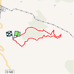

Length
6.4 km

Max alt
484 m

Uphill gradient
147 m
Km-Effort
8.4 km

Min alt
351 m

Downhill gradient
143 m
Boucle
Yes
Creation date :
2018-04-17 16:40:43.044
Updated on :
2018-04-17 16:40:43.044
1h48
Difficulty : Unknown

FREE GPS app for hiking
 SityTrail
IGN / Geographical institutes
SityTrail Plus
The world is yours!
About
Trail Walking of 6.4 km to be discovered at Provence-Alpes-Côte d'Azur, Var, Le Beausset. This trail is proposed by CSMSRANDOS.
Positioning
Country:
France
Region :
Provence-Alpes-Côte d'Azur
Department/Province :
Var
Municipality :
Le Beausset
Location:
Unknown
Start:(Dec)
Start:(UTM)
728520 ; 4790838 (31T) N.
Comments